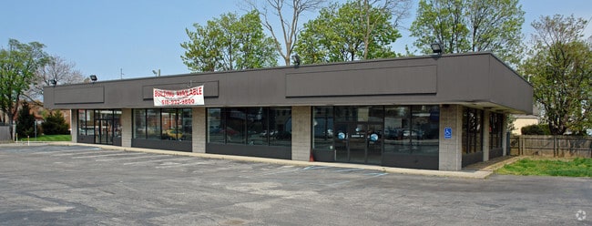
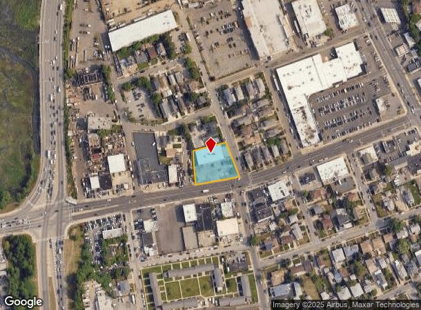
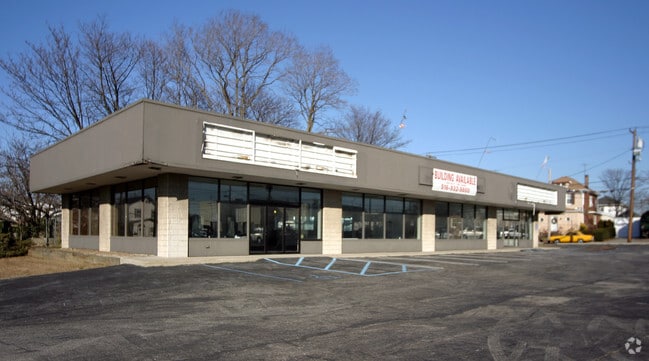
Property Record
711 Burnside Ave, Lawrence, NY 11559
NEARBY LISTINGS FOR SALE OR LEASE
Property Detail
711 Burnside Ave
2089-40-011-00-0124-0
124-125
Commercialnec
Nassau
AE
New York
36059C0301G
124-1
2025
0.59 AC
2025
Southern Nassau
411000
Long Island (New York)
7,360 SF
Nassau County-Suffolk County, NY
DEMOGRAPHICS near 711 Burnside Ave
1 Mile
3 Mile
5 Mile
2024 Total Population
21,931
160,715
448,088
2029 Population
21,253
153,001
424,786
Pop Growth 2024-2029
(3.09%)
(4.80%)
(5.20%)
Average Age
37
39
41
2024 Total Households
6,591
50,050
146,514
HH Growth 2024-2029
(3.05%)
(4.94%)
(5.34%)
Median Household Inc
$86,712
$84,854
$91,051
Avg Household Size
3.20
3.00
2.90
2024 Avg HH Vehicles
2.00
1.00
1.00
Median Home Value
$767,326
$722,379
$647,958
Median Year Built
1952
1958
1955
Nearby Places
- Restaurants
- Banks
- Shops
- Fitness
- Groceries
PUBLIC TRANSPORTATION
TRANSIT/SUBWAY
Lawrence Station (Far Rockaway Branch - Long Island Rail Road)
DRIVE
WALK
Distance
Lawrence Station (Far Rockaway Branch - Long Island Rail Road)
2 min
13 min
0.6 mi
Cedarhurst Station (Far Rockaway Branch - Long Island Rail Road)
DRIVE
WALK
Distance
Cedarhurst Station (Far Rockaway Branch - Long Island Rail Road)
3 min
18 min
0.9 mi
COMMUTER RAIL
Lawrence Station (Far Rockaway Branch - Long Island Rail Road)
DRIVE
WALK
Distance
Lawrence Station (Far Rockaway Branch - Long Island Rail Road)
2 min
13 min
0.7 mi
Inwood Station (Far Rockaway Branch - Long Island Rail Road)
DRIVE
WALK
Distance
Inwood Station (Far Rockaway Branch - Long Island Rail Road)
2 min
0.9 mi
AIRPORT
John F Kennedy International
DRIVE
WALK
Distance
John F Kennedy International
16 min
8.2 mi
LaGuardia
DRIVE
WALK
Distance
LaGuardia
26 min
14.0 mi
Newark Liberty International
DRIVE
WALK
Distance
Newark Liberty International
52 min
33.7 mi
Freight Ports
NY - Red Hook Container Terminal
DRIVE
WALK
Distance
NY - Red Hook Container Terminal
36 min
18.1 mi
Nearby Properties
Address
Land Use
TOTAL SIZE
Lot Size
Zoning
Address
Land Use
TOTAL SIZE
Lot Size
Zoning
229.51 AC
PARKUS
Address
Land Use
TOTAL SIZE
Lot Size
Zoning
111.98 AC
PARK
Address
Land Use
TOTAL SIZE
Lot Size
Zoning
182.50 AC
M1-1
Address
Land Use
TOTAL SIZE
Lot Size
Zoning
124.60 AC
M1-1
Address
Land Use
TOTAL SIZE
Lot Size
Zoning
294.47 AC
PARK
Address
Land Use
TOTAL SIZE
Lot Size
Zoning
52.80 AC
PARK
Address
Land Use
TOTAL SIZE
Lot Size
Zoning
188,656 SF
5.78 AC
R5
Address
Land Use
TOTAL SIZE
Lot Size
Zoning
188.92 AC
PARK
Address
Land Use
TOTAL SIZE
Lot Size
Zoning
27.23 AC
PARK
Address
Land Use
TOTAL SIZE
Lot Size
Zoning
64,618 SF
8.04 AC
Address
Land Use
TOTAL SIZE
Lot Size
Zoning
661,319 SF
50.43 AC
R5
Address
Land Use
TOTAL SIZE
Lot Size
Zoning
93.35 AC
PARK
Address
Land Use
TOTAL SIZE
Lot Size
Zoning
14.91 AC
C4-4
Address
Land Use
TOTAL SIZE
Lot Size
Zoning
154,051 SF
4.05 AC
R5
Address
Land Use
TOTAL SIZE
Lot Size
Zoning
119,788 SF
3.90 AC
R5
Address
Land Use
TOTAL SIZE
Lot Size
Zoning
178,870 SF
7.60 AC
M1-1
Address
Land Use
TOTAL SIZE
Lot Size
Zoning
5,296 SF
37.42 AC
PARK
Address
Land Use
TOTAL SIZE
Lot Size
Zoning
213,338 SF
2.91 AC
R3X
Address
Land Use
TOTAL SIZE
Lot Size
Zoning
449,000 SF
5.15 AC
R6
Address
Land Use
TOTAL SIZE
Lot Size
Zoning
155,875 SF
0.90 AC
R6
Address
Land Use
TOTAL SIZE
Lot Size
Zoning
6,077 SF
19.66 AC
PARK
Address
Land Use
TOTAL SIZE
Lot Size
Zoning
97,190 SF
1.75 AC
R3X
Address
Land Use
TOTAL SIZE
Lot Size
Zoning
16.49 AC
PARK
Address
Land Use
TOTAL SIZE
Lot Size
Zoning
334,586 SF
12.25 AC
R5
Address
Land Use
TOTAL SIZE
Lot Size
Zoning
75,410 SF
5.12 AC
M1-1
Address
Land Use
TOTAL SIZE
Lot Size
Zoning
77,576 SF
1.38 AC
R5
Address
Land Use
TOTAL SIZE
Lot Size
Zoning
253,000 SF
7.97 AC
R5
Address
Land Use
TOTAL SIZE
Lot Size
Zoning
141,782 SF
7.39 AC
M1-1
Address
Land Use
TOTAL SIZE
Lot Size
Zoning
14.58 AC
M1-1
Address
Land Use
TOTAL SIZE
Lot Size
Zoning
1,000 SF
27.14 AC
PARK
The World's #1 Commercial Real Estate Marketplace
Connect with us
© 2025 CoStar Group
The information above has been obtained from sources believed reliable. While we do not doubt its accuracy we have not verified it and make no guarantee, warranty or representation about it. It is your responsibility to independently confirm its accuracy and completeness. Any projections, opinions, assumptions, or estimates used are for example only and do not represent the current or future performance of the property. The value of this transaction to you depends on tax and other factors which should be evaluated by your tax, financial, and legal advisors. You and your advisors should conduct a careful, independent investigation of the property to determine to your satisfaction the suitability of the property for your needs.